Thanks to a friend on FaceBook, I found this great video of San Francisco from 1955. It’s a travelog sort of film that makes San Francisco look like Disneyland in many ways. If you think you know the City, see how many places you’ll find that are different today than they were then. I honestly got all of them even though Sutro Baths was closed just after I was born. I’d like to do a remake of this film using the same voice over and locations, but with today’s scenes. Sounds like fun anyone in on it with me?
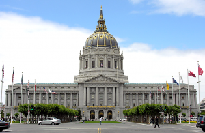
49 Mile Drive: Stop One, Civic Center
 It was a bit of a cold day for us, but we decided to travel down to the main library last Sunday. Little did I realize until we were inside the library that this was the first stop on the 49 Mile Drive, so it was time to pull out the camera.
Big bonus, it was on a Sunday and we could park on the street for free. Big bummer, the homeless people outnumbered the bubblegum stuck to the sidewalks. One thing at least when you’re walking with a kid in a stroller is that homeless people have an understanding, don’t ask for money or be aggressive. I’ve seen this happen many times. I’ll even let my wife walk ahead a few feet and they’ll never ask her for money or a cigarette or anything else, but when I go buy they’re all over me.
Stop one, it’s nice in spite of the homeless people, but there isn’t much else to say about it. Here’s a few of the sites to see there:
- City Hall: Rather stately looking after you’ve finished going through security and you get lots of echos which you’ll have to keep your kids from screaming just hear their scream bounce back at them sending security guards running at you with one hand on their guns.
- Bill Graham Civic Auditorium: I’ve spent many a night there, even roadied a few shows for bands there. It’s a great place for live acts that has a small arena feel, but you can actually make out the people in the band from the top seats. Acoustics aren’t bad for this place either. Side note: The SpaceCon III Star Trek Convention was held here in 1976 and the Warriors used to play basketball here for a short time.
- Asian Art Museum: I can’t really say much about it because I haven’t been here since it moved from the DeYoung Museum. It was never very crowded when it was there and it sounds like they’re still having trouble attracting people, but if you’re into Asian art, it’s a cool place to visit.
- Davies Symphony Hall: Ah the place to see and be seen. It was kind of surreal the last time I was there as I saw Huey Lewis and Chris Isaak talking to Willie Brown. This place is serious symphony and you’ll never find an electric guitar in this place.
- War Memorial Opera House: It seems to be the home of the San Francisco Ballet and nothing else. It looked locked up tighter than Fort Knox when we walked by.
- SF Main Library: What can I say other than what I’ve said before. This place is gorgeous inside, it has a cafe and rotating exhibits as well as free wi-fi. Well, there are the homeless people who wander in to use the restrooms or to get out of the cold until someone throws them out which they usually don’t, but they’ve got a HUGE selection of books, audio, video and free computers to use if you’re on a low income and can’t afford one for yourself.
[mappress mapid=”7″]And that ends it for step one. It turns out that the 49 mile drive has had it’s locations changed over the years with the changing of landmarks over the years. I’m working off the current list for this trip. In the photo library bellow there are a few pics from our trip and that same gallery will be update along the way. Next stop, Cathedral Hill!
[nggallery id=10]
The Gauntlet Has Been Thrown Down!
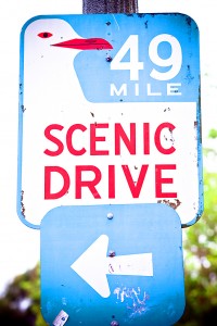
 I was issued a challenge today for the site from my friend Mike Gunn. He suggested that I travel the 49 mile scenic drive throughout San Francisco and add some pics and video clips. I like the idea because it will give me lots to talk about and at least 49 different posts so that should keep things going for quite a while. I accept the challenge!
For those of you who aren’t aware of this it was started on September 14, 1938 in anticipation of the 1939 World’s Fair that coincided with the opening of the Golden Gate Bridge and Bay Bridge which was good because otherwise you would have had to take a ferry to get to the fair. Not a bad idea, unless you’ve ever been out on the bay in bad weather. Even I can get seasick from a cruise when the winds kick up as you get close to South Beach harbor.
Rex May designed the sign that you might still see around in a few places many of which have been stolen by vandals even though a reproduction of the sign and be purchased at the City Hall Gift Shop. The route starts at Hayes and Van Ness and travels all around the city to show off to tourists how great the city is ending at former fairgrounds for the 1939 World’s Fair on Treasure Island. I’m not sure how long it would take to drive 49 miles within San Francisco, but something tells me it’s going to take more than an hour. Next week I’ll start things off and I like the idea because I haven’t been to Treasure Island in almost 10 years.
If you click on the picture you’ll see a map of the route courtesy of Google. Thanks for the idea Mike!

